/r/TropicalWeather


The intent of this subreddit is to provide a centralized location to discuss tropical cyclone, including their climatology, their development, their movement, and their impacts to life, property, and the environment. The moderator staff strives to minimize excessive speculation and fearmongering and to distribute and emphasize lifesaving information from official sources.
Current discussions: Global Outlook Fengal Robyn
Current discussions
Global Outlook
Northern Indian
04B — Fengal
Southern Indian
03S — Robyn
Filter By Basin
Northern Atlantic
Eastern Pacific
Central Pacific
Western Pacific
Northern Indian
Southern Hemisphere
Clear filters
Important Threads and Links
Tropical Weather Discord
Tropical Weather Twitter
Hurricane Supplies Megathread
Tropical Weather Wiki
Twitter List of WX accounts
Comprehensive Tropical Cyclone Links List
Weather Multireddit
Subreddit Rules
Posts must be related to tropical cyclones.
Do not post duplicate tracking threads.
Do not post a new thread for every NHC/RSMC update.
Do not attack, troll, or threaten other users.
Do not post sexually explicit content or spam.
Do not post hard paywalled content.
Do not discuss politics, regardless of level.
Do not post no-/low-effort posts or memes.
Do not post intentionally misleading information.
Do not fear-monger.
Do not excessively speculate.
Do not post model data or ask for forecast advice beyond 5 days (120 hours) in the future.
Do not post content from prohibited sources, including AccuWeather, Force Thirteen, and Direct Weather.
Contact us to be verified as a meteorologist!
This subreddit is night mode compatible!
/r/TropicalWeather
153,345 Subscribers
95W (Invest — South China Sea)
Latest Observation
Last updated: Tuesday, 3 December — 7:00 AM Indochina Time (ICT; 00:00 UTC)
| ATCF | 7:00 AM ICT (00:00 UTC) | |
|---|---|---|
| Current location: | 6.0°N 107.7°E | |
| Relative location: | 425 km (264 mi) SSE of Bạc Liêu, Vietnam | |
| Forward motion: | ▼ | SW (235°) at 7 km/h (4 knots) |
| Maximum winds: | 30 km/h (15 knots) | |
| Minimum pressure: | 1006 millibars (29.71 inches) | |
| 2-day potential: (through 7AM Thu) | low (10 percent) | |
| 7-day potential: (through 7AM Mon) | low (10 percent) |
Outlook discussion
The Joint Typhoon Warning Center has not yet added this system to its Pacific outlook discussion.
Official information
Japan Meteorological Agency
Joint Typhoon Warning Center (United States)
Radar imagery
Not available
Radar imagery is not currently available for this system.
Satellite imagery
Storm-specific imagery
- Tropical Tidbits: Visible / Shortwave Infrared
- Tropical Tidbits: Enhanced Infrared
- Tropical Tidbits: Enhanced Infrared (Dvorak)
- Tropical Tidbits: Water Vapor
- CIMSS: Multiple bands
- RAMMB: Multiple bands
- Navy Research Laboratory: Multiple bands
Regional imagery
Cooperative Institute for Meteorological Satellite Studies (CIMSS)
Weather Nerds
Analysis graphics and data
Wind analyses
- EUMETSAT: Advanced Scatterometer Data
Sea-surface Temperatures
- NOAA OSPO: Sea Surface Temperature Contour Charts
- Tropical Tidbits: Ocean Analysis
Model guidance
Storm-specific guidance
- Tropical Tidbits
- State University of New York at Albany
- National Center for Atmospheric Research (NCAR)
- Weather Nerds
Regional single-model guidance
Regional ensemble model guidance
03:42 UTC
Global Tropical Outlook & Discussion: 2-8 December 2024
Current discussions
Last updated: Monday, 2 December — 15:00 Coordinated Universal Time (UTC)
North Indian
- 04B — Fengal (Bay of Bengal)
Satellite imagery
Regional imagery
Infrared imagery
- Western Pacific
- Eastern Pacific
- Northern Atlantic
- Northern Indian (Arabian Sea)
- Northern Indian (Bay of Bengal)
- Southwestern Indian
- Southeastern Indian
Model guidance
Regional guidance (GFS)
Information sources
Regional Specialized Meteorological Centers (RSMC)
Other sources
Global outlooks
Climate Prediction Center
15:33 UTC
Fengal (04B — Bay of Bengal)
Latest Observation
Last updated: Tuesday, 3 December — 5:30 AM India Standard Time (IST; 00:00 UTC)
| ATCF | 5:30 AM IST (00:00 UTC) | |
|---|---|---|
| Current location: | 13.7°N 75.6°E | |
| Relative location: | 26 km (16 mi) S of Shimoga, Karnataka (India) | |
| Forward motion: | ▼ | WNW (300°) at 23 km/h (12 knots) |
| Maximum winds: | 35 km/h (20 knots) | |
| Minimum pressure: | ▼ | 1002 millibars (29.59 inches) |
| 2-day potential: (through 5AM Thu) | low (10 percent) | |
| 7-day potential: (through 5AM Mon) | low (10 percent) |
Official information
India Meteorological Department
Joint Typhoon Warning Center (United States)
Radar imagery
India Meteorological Department
Satellite imagery
Floater imagery
Single bandwidth imagery
- Tropical Tidbits: Visible / shortwave infrared
- Tropical Tidbits: Enhanced infrared
- Tropical Tidbits: Enhanced infrared (Dvorak enhancement)
- Tropical Tidbits: Water vapor
Multiple bandwidth imagery
The options to select individual bandwidths on each of the following websites may vary.
Regional imagery
- CIMSS: Enhanced Infrared
- CIMSS: Water vapor
- CIMSS: Visible
Analysis products
Best track data
Surface analysis products
India Meteorological Department
Wind analysis and storm intensity estimation products
- NESDIS: Dvorak Fix Bulletins
- NESDIS: Dvorak Fix History
- NESDIS: Multi-platform Surface Wind Analysis
- CIMSS: Advanced Dvorak Technique (ADT)
- CIMSS: Tropical Cyclone Intensity Consensus (SATCON)
- CIMSS: SATCON Intensity History
- EUMETSAT: Advanced Scatterometer Data
Sea-surface temperature analysis products
- NOAA OSPO: Sea Surface Temperature Contour Charts
- Tropical Tidbits: Ocean Analysis
Model products
Disturbance-specific model guidance
Storm-centered guidance
Track guidance
Track and intensity guidance
Regional single-model guidance
- Tropical Tidbits: GFS
- Tropical Tidbits: ECMWF
- Tropical Tidbits: CMC
- Tropical Tidbits: ICON
- India Meteorological Department Several models
Regional ensemble model guidance
Weather Nerds: GEFS (120 hours)
Weather Nerds: ECENS (120 hours)
20:21 UTC
Robyn (03S/01U — Southeastern Indian)
Latest Observation
Last updated: Sunday, 1 December — 6:30 PM Cocos Island Time (CCT; 12:00 UTC)
| ATCF | 6:30 PM CCT (12:00 UTC) | |
|---|---|---|
| Current location: | 19.0°S 93.0°E | |
| Relative location: | 865 km (537 mi) SSW of West Island, Cocos Islands (Australia) | |
| Forward motion: | ▲ | SW (240°) at 12 km/h (7 knots) |
| Maximum winds: | 45 km/h (25 knots) | |
| Minimum pressure: | 1004 millibars (29.65 inches) |
Official forecasts
NOTE: Neither Australia's Bureau of Meteorology (BOM) nor the Joint Typhoon Warning Center (JTWC) are issuing advisories for this system.
Official information
Bureau of Meteorology (Australia)
Joint Typhoon Warning Center (United States)
Radar imagery
Not available
Radar imagery is not currently available for this system.
Satellite imagery
Floater imagery
Single bandwidth imagery
- Tropical Tidbits: Visible / shortwave infrared
- Tropical Tidbits: Enhanced infrared
- Tropical Tidbits: Enhanced infrared (Dvorak enhancement)
- Tropical Tidbits: Water vapor
Multiple bandwidth imagery
The options to select individual bandwidths on each of the following websites may vary.
Regional imagery
- CIMSS: Enhanced Infrared
- CIMSS: Water vapor
- CIMSS: Visible
Analysis products
Best track data
Wind analysis and storm intensity estimation products
- NESDIS: Dvorak Fix Bulletins
- NESDIS: Dvorak Fix History
- NESDIS: Multi-platform Surface Wind Analysis
- CIMSS: Advanced Dvorak Technique (ADT)
- CIMSS: Tropical Cyclone Intensity Consensus (SATCON)
- CIMSS: SATCON Intensity History
- EUMETSAT: Advanced Scatterometer Data
Sea-surface temperature analysis products
- NOAA OSPO: Sea Surface Temperature Contour Charts
- Tropical Tidbits: Ocean Analysis
Model products
Storm-specific model guidance
Storm-centered guidance
Track guidance
Track and intensity guidance
Regional single-model guidance
Regional ensemble model guidance
Weathernerds: GEFS (120 hours)
Weathernerds: ECENS (120 hours)
12:23 UTC
Global Tropical Outlook & Discussion: 25 November - 1 December 2024
Current discussions
Last updated: Sunday, 1 December — 17:00 Coordinated Universal Time (UTC)
North Indian
- 04B — Fengal (Bay of Bengal)
South Indian
- 03S — Robyn (Southeastern Indian Ocean)
Satellite imagery
Regional imagery
Infrared imagery
- Western Pacific
- Eastern Pacific
- Northern Atlantic
- Northern Indian (Arabian Sea)
- Northern Indian (Bay of Bengal)
- Southwestern Indian
- Southeastern Indian
Model guidance
Regional guidance (GFS)
Information sources
Regional Specialized Meteorological Centers (RSMC)
Other sources
Global outlooks
Climate Prediction Center
17:24 UTC
What storms do you think were SEVERELY underestimated?
I'm talking about these types of storms: Nisha-Orama (Officially a Category 3), Hina (Officially a Category 4), Dianmu (Officially 915 hPA - how????) Olaf (2005), and more. I put satellite images of the storms which literally just shows the underestimation, you can tell they're stronger.
02:07 UTC
storms in november
Why do the strongest typhoons often hit the Philippines in November? Super Typhoon Haiyan struck on November 8, Super Typhoon Goni on November 1, and this month alone, the Philippines has already been hit by four typhoons, and two of them are super typhoons. (im a newbie when it comes to tropical cyclones, i was just curious)
20:08 UTC
What little remains of Sara colliding with a cold front
01:09 UTC


Global Tropical Outlook & Discussion: 18-25 November 2024
Current discussions
Last updated: Saturday, 23 November — 21:00 Coordinated Universal Time (UTC)
North Indian
- 99B — Invest (Bay of Bengal)
South Indian
- 96S — Invest (Southeastern Indian Ocean)
Satellite imagery
Regional imagery
Infrared imagery
- Western Pacific
- Eastern Pacific
- Northern Atlantic
- Northern Indian (Arabian Sea)
- Northern Indian (Bay of Bengal)
- Southwestern Indian
- Southeastern Indian
Model guidance
Regional guidance (GFS)
Information sources
Regional Specialized Meteorological Centers (RSMC)
Other sources
Global outlooks
Climate Prediction Center
12:14 UTC
Man-yi (25W — South China Sea)
Latest observation
Last updated: Tuesday, 19 November — 1:00 PM Indochina Time (ICT; 06:00 UTC)
| JTWC Warning #42 | 1:00 PM ICT (06:00 UTC) | |
|---|---|---|
| Current location: | 18.8°N 113.0°E | |
| Relative location: | 275 km (171 mi) E of Wanning, Hainan (China) | |
| Forward motion: | WSW (265°) at 19 km/h (10 knots) | |
| Maximum winds: | ▼ | 55 km/h (30 knots) |
| Intensity (SSHWS): | ▼ | Tropical Depression |
| Intensity (JMA): | Tropical Storm [see note] | |
| Minimum pressure: | ▲ | 1002 millibars (29.59 inches) |
^NOTE ^- ^Based ^on ^the ^Japan ^Meteorological ^Agency's ^ten-minute ^maximum ^sustained ^wind ^estimate ^of ^75 ^kilometers ^per ^hour ^(40 ^knots).
Official forecasts
Japan Meteorological Agency
Last updated: Tuesday, 19 November — 4:00 PM ICT (09:00 UTC)
| Hour | Date | Time | Intensity | Winds | Lat | Long | |||
|---|---|---|---|---|---|---|---|---|---|
| — | UTC | ICT | JMA | knots | km/h | °N | °E | ||
| 00 | 19 Nov | 09:00 | 4PM Tue | Tropical Storm | 40 | 75 | 18.5 | 112.5 | |
| 12 | 19 Nov | 21:00 | 4AM Wed | Tropical Storm | ▼ | 35 | 65 | 17.5 | 110.8 |
| 24 | 20 Nov | 09:00 | 4PM Wed | Tropical Depression | ▼ | 30 | 55 | 16.3 | 109.9 |
Joint Typhoon Warning Center
Last updated: Tuesday, 19 November — 4:00 PM ICT (09:00 UTC)
| Hour | Date | Time | Intensity | Winds | Lat | Long | |||
|---|---|---|---|---|---|---|---|---|---|
| — | UTC | ICT | Saffir-Simpson | knots | km/h | °N | °E | ||
| 00 | 19 Nov | 06:00 | 1PM Tue | Tropical Depression | 30 | 55 | 18.8 | 113.0 | |
| 12 | 19 Nov | 18:00 | 1AM Wed | Tropical Depression | ▼ | 25 | 45 | 17.9 | 111.2 |
| 24 | 20 Nov | 06:00 | 1PM Wed | Remnant Low | ▼ | 20 | 35 | 16.7 | 109.3 |
| 36 | 20 Nov | 18:00 | 1AM Thu | Dissipated |
Official information
Japan Meteorological Agency
Joint Typhoon Warning Center (United States)
Other sources
Radar imagery
National Meteorological Center (China)
National Center for Hydrometeorological Forecasting (Vietnam)
Satellite imagery
Floater imagery
Single bandwidth imagery
- Tropical Tidbits: Visible / shortwave infrared
- Tropical Tidbits: Enhanced infrared
- Tropical Tidbits: Enhanced infrared (Dvorak enhancement)
- Tropical Tidbits: Water vapor
Multiple bandwidth imagery
The options to select individual bandwidths on each of the following websites may vary.
Regional imagery
Cooperative Institute for Meteorological Satellite Studies (CIMSS)
Weather Nerds
Analysis products
Best track data
Surface analysis products
Japan Meteorological Agency
Wind analysis and storm intensity estimation products
- NESDIS: Dvorak Fix History
- NESDIS: Multi-platform Surface Wind Analysis
- CIMSS: Advanced Dvorak Technique (ADT)
- CIMSS: Tropical Cyclone Intensity Consensus (SATCON)
- CIMSS: SATCON Intensity History
- EUMETSAT: Advanced Scatterometer Data
Sea-surface temperature analysis products
- NOAA OSPO: Sea Surface Temperature Contour Charts
- Tropical Tidbits: Ocean Analysis
Model products
Disturbance-specific model guidance
Storm-centered guidance
Track guidance
Track and intensity guidance
Regional single-model guidance
Regional ensemble model guidance
Weather Nerds: GEFS (120 hours)
Weather Nerds: ECENS (120 hours)
06:17 UTC
NHC final update on Tropical Storm Sara — Saturday, 16 November
15:23 UTC
Supertyphoon Man-yi attaining Category 5 strength right before the sun sets
10:30 UTC
timing of wind impacts from hurricanes/TStorms? Exit?
I understand airports can close due to wind, flooding, power outages, etc, but i'm mostly curious about winds. What are the time-windows which typically cause delays and cancellations at airports due to winds? Hrs or days?
Example, TropStorm 19 might be a hurricane, likely passing NE just south of Cancun Monday AM, I'm curious when the these winds might begin and when they might be gone. I see Arrival Time of TS Winds charts, but how long do those periods last? Would winds be gone by Tue in the example above?
18:00 UTC
Sara (19L — Western Caribbean Sea)
Latest observation
Last updated: Sunday, 17 November — 9:00 PM Central Standard Time (CST; 03:00 UTC)
| NHC Advisory #18 | 9:00 PM CST (03:00 UTC) | |
|---|---|---|
| Current location: | 18.1°N 90.7°W | |
| Relative location: | 490 km (304 mi) WNW of La Ceiba, Honduras | |
| Forward motion: | WNW (300°) at 20 km/h (11 knots) | |
| Maximum winds: | 45 km/h (25 knots) | |
| Intensity: | Tropical Depression | |
| Minimum pressure: | 1004 millibars (29.65 inches) |
Official forecast
Last updated: Sunday, 17 November — 6:00 PM CST (00:00 UTC)
| Hour | Date | Time | Intensity | Winds | Lat | Long | |||
|---|---|---|---|---|---|---|---|---|---|
| - | UTC | CST | Saffir-Simpson | knots | km/h | °N | °W | ||
| 00 | 18 Nov | 00:00 | 6PM Sun | Tropical Depression | 25 | 45 | 18.1 | 90.7 | |
| 12 | 18 Nov | 12:00 | 6AM Mon | Remnant Low | ▼ | 20 | 35 | 19.3 | 92.0 |
| 24 | 19 Nov | 00:00 | 6PM Mon | Dissipated |
Official information
National Hurricane Center
Text products
Productos de texto (en español)
Graphical products
- Forecast graphic
- Experimental new forecast graphic (with inland advisories)
- Interactive forecast graphic
- Wind speed probabilities
- Arrival time of winds
Servicio Meteorológico Nacional (Mexico)
Aircraft reconnaissance
National Hurricane Center
Radar imagery
Servicio Meteorológico Nacional (Mexico)
Satellite imagery
Storm-specific imagery
- Tropical Tidbits: Visible / Shortwave Infrared
- Tropical Tidbits: Enhanced Infrared
- Tropical Tidbits: Enhanced Infrared (Dvorak)
- Tropical Tidbits: Water Vapor
- CIMSS: Multiple bands
- RAMMB: Multiple bands
- Navy Research Laboratory: Multiple bands
Regional imagery
NOAA GOES Image Viewer
Cooperative Institute for Meteorological Satellite Studies (CMISS)
Tropical Tidbits
Weather Nerds
Analysis graphics and data
Wind analyses
- NESDIS: Dvorak Fix Bulletins
- NESDIS: Dvorak Fix History
- NESDIS: Multi-platform Surface Wind Analysis
- CIMSS: Advanced Dvorak Technique (ADT)
- CIMSS: Tropical Cyclone Intensity Consensus (SATCON)
- CIMSS: SATCON Intensity History
- EUMETSAT: Advanced Scatterometer Data
Sea-surface Temperatures
- NOAA OSPO: Sea Surface Temperature Contour Charts
- Tropical Tidbits: Ocean Analysis
Model guidance
Storm-specific guidance
- Tropical Tidbits
- State University of New York at Albany
- National Center for Atmospheric Research (NCAR)
- Weather Nerds
Regional single-model guidance
Regional ensemble model guidance
Weather Nerds: GEFS (120 hours)
Weather Nerds: ECENS (120 hours)
17:55 UTC
Bheki (02S — Southwestern Indian)
Latest Observation
Last updated: Saturday, 23 November — 4:00 PM Reunion Time (RET; 12:00 UTC)
| ATCF | 4:00 PM RET (12:00 UTC) | |
|---|---|---|
| Current location: | 23.3°S 52.1°E | |
| Relative location: | 439 km (273 mi) SW of Saint-Denis, Réunion (France) | |
| Forward motion: | ▼ | SE (150°) at 7 km/h (4 knots) |
| Maximum winds: | 35 km/h (20 knots) | |
| Minimum pressure: | 1007 millibars (29.74 inches) |
Official forecast
Both Météo-France and the Joint Typhoon Warning Center have assessed this system to have degenerated into a remnant low and have thus discontinued issuing forecast advisory products for it. This post will only update until this system's position and intensity are no longer being updated in the Automated Tropical Cyclone Forecast (ATCF) system.
Official information
Meteo France (RSMC Reunion)
Joint Typhoon Warning Center (United States)
Radar imagery
Not available
Radar imagery is not currently available for this system.
Satellite imagery
Floater imagery
Single bandwidth imagery
- Tropical Tidbits: Visible / shortwave infrared
- Tropical Tidbits: Enhanced infrared
- Tropical Tidbits: Enhanced infrared (Dvorak enhancement)
- Tropical Tidbits: Water vapor
Multiple bandwidth imagery
The options to select individual bandwidths on each of the following websites may vary.
Regional imagery
- CIMSS: Enhanced Infrared
- CIMSS: Water vapor
- CIMSS: Visible
Analysis products
Best track data
Wind analysis and storm intensity estimation products
- NESDIS: Dvorak Fix Bulletins
- NESDIS: Dvorak Fix History
- NESDIS: Multi-platform Surface Wind Analysis
- CIMSS: Advanced Dvorak Technique (ADT)
- CIMSS: Tropical Cyclone Intensity Consensus (SATCON)
- CIMSS: SATCON Intensity History
- EUMETSAT: Advanced Scatterometer Data
Sea-surface temperature analysis products
- NOAA OSPO: Sea Surface Temperature Contour Charts
- Tropical Tidbits: Ocean Analysis
Model products
Storm-specific model guidance
Storm-centered guidance
Track guidance
Track and intensity guidance
Regional single-model guidance
Regional ensemble model guidance
Weathernerds: GEFS (120 hours)
Weathernerds: ECENS (120 hours)
15:55 UTC
Toraji (26W — South China Sea)
Latest observation
Last updated: Thursday, 14 November — 8:00 AM Philippine Standard Time (PhST; 00:00 UTC)
| JTWC Warning #20 | 8:00 AM PhST (00:00 UTC) | |
|---|---|---|
| Current location: | 21.0°N 114.0°E | |
| Relative location: | 148 km (92 mi) S of Hong Kong | |
| Forward motion: | WSW (255°) at 7 km/h (4 knots) | |
| Maximum winds: | ▼ | 45 km/h (25 knots) |
| Intensity (SSHWS): | Tropical Depression | |
| Intensity (JMA): | Tropical Storm [see note] | |
| Minimum pressure: | ▲ | 1005 millibars (29.68 inches) |
^NOTE ^- ^Based ^on ^the ^Japan ^Meteorological ^Agency's ^ten-minute ^maximum ^sustained ^wind ^estimate ^of ^65 ^kilometers ^per ^hour ^(35 ^knots).
Official forecasts
Japan Meteorological Agency
Last updated: Thursday, 14 November — 2:00 PM PhST (06:00 UTC)
| Hour | Date | Time | Intensity | Winds | Lat | Long | |||
|---|---|---|---|---|---|---|---|---|---|
| — | UTC | PhST | JMA | knots | km/h | °N | °E | ||
| 00 | 14 Nov | 06:00 | 2PM Thu | Tropical Storm | 35 | 65 | 21.2 | 113.9 | |
| 12 | 14 Nov | 18:00 | 2AM Fri | Tropical Depression | ▼ | 30 | 55 | 21.2 | 113.2 |
| 24 | 15 Nov | 06:00 | 2PM Fri | Tropical Depression | 30 | 55 | 21.0 | 112.6 |
Joint Typhoon Warning Center
Last updated: Thursday, 14 November — 11:00 AM PhST (03:00 UTC)
NOTE: The JTWC has issued its final advisory for this system.
| Hour | Date | Time | Intensity | Winds | Lat | Long | |||
|---|---|---|---|---|---|---|---|---|---|
| — | UTC | PhST | Saffir-Simpson | knots | km/h | °N | °E | ||
| 00 | 14 Nov | 00:00 | 8AM Thu | Tropical Depression | 25 | 45 | 21.0 | 114.0 | |
| 12 | 14 Nov | 12:00 | 8PM Thu | Remnant Low | ▼ | 20 | 35 | 20.9 | 113.4 |
| 24 | 15 Nov | 00:00 | 8AM Fri | Remnant Low | ▼ | 15 | 30 | 20.7 | 113.2 |
Official information
Japan Meteorological Agency
Joint Typhoon Warning Center (United States)
Philippine Atmospheric, Geophysical, and Astronomical Services Administration
National Meteorological Center (China)
Hong Kong Observatory
English
Chinese (simplified)
Radar imagery
Philippine Atmospheric, Geophysical, and Astronomical Services Administration
Satellite imagery
Floater imagery
Single bandwidth imagery
- Tropical Tidbits: Visible / shortwave infrared
- Tropical Tidbits: Enhanced infrared
- Tropical Tidbits: Enhanced infrared (Dvorak enhancement)
- Tropical Tidbits: Water vapor
Multiple bandwidth imagery
The options to select individual bandwidths on each of the following websites may vary.
Regional imagery
Cooperative Institute for Meteorological Satellite Studies (CIMSS)
Weather Nerds
Analysis products
Best track data
Surface analysis products
Japan Meteorological Agency
Wind analysis and storm intensity estimation products
- NESDIS: Dvorak Fix History
- NESDIS: Multi-platform Surface Wind Analysis
- CIMSS: Advanced Dvorak Technique (ADT)
- CIMSS: Tropical Cyclone Intensity Consensus (SATCON)
- CIMSS: SATCON Intensity History
- EUMETSAT: Advanced Scatterometer Data
Sea-surface temperature analysis products
- NOAA OSPO: Sea Surface Temperature Contour Charts
- Tropical Tidbits: Ocean Analysis
Model products
Disturbance-specific model guidance
Storm-centered guidance
Track guidance
Track and intensity guidance
Regional single-model guidance
Regional ensemble model guidance
Weather Nerds: GEFS (120 hours)
Weather Nerds: ECENS (120 hours)
10:16 UTC
19L (Western Caribbean Sea)
Latest observation
Last updated: Thursday, 14 November — 10:00 AM Eastern Standard Time (EST; 15:00 UTC)
| NHC Advisory #4 | 10:00 AM EST (15:00 UTC) | |
|---|---|---|
| Current location: | 15.7°N 82.6°W | |
| Relative location: | 449 km (279 mi) E of La Ceiba, Honduras | |
| Forward motion: | W (265°) at 22 km/h (12 knots) | |
| Maximum winds: | 55 km/h (30 knots) | |
| Intensity: | Tropical Depression | |
| Minimum pressure: | 1004 millibars (29.65 inches) |
Official forecast
Last updated: Thursday, 14 November — 7:00 AM EST (12:00 UTC)
| Hour | Date | Time | Intensity | Winds | Lat | Long | |||
|---|---|---|---|---|---|---|---|---|---|
| - | UTC | EST | Saffir-Simpson | knots | km/h | °N | °W | ||
| 00 | 14 Nov | 12:00 | 7AM Thu | Tropical Depression | 30 | 55 | 15.7 | 82.6 | |
| 12 | 15 Nov | 00:00 | 7PM Thu | Tropical Storm | ▲ | 35 | 65 | 15.7 | 83.7 |
| 24 | 15 Nov | 12:00 | 7AM Fri | Tropical Storm ^1 | ▲ | 40 | 75 | 15.9 | 84.9 |
| 36 | 16 Nov | 00:00 | 7PM Fri | Tropical Storm ^1 | 40 | 75 | 15.9 | 85.4 | |
| 48 | 16 Nov | 12:00 | 7AM Sat | Tropical Storm ^1 | 40 | 75 | 15.9 | 85.8 | |
| 60 | 17 Nov | 00:00 | 7PM Sat | Tropical Storm ^1 | ▲ | 45 | 85 | 16.0 | 86.2 |
| 72 | 17 Nov | 12:00 | 7AM Sun | Tropical Storm ^2 | 45 | 85 | 16.2 | 87.0 | |
| 96 | 18 Nov | 12:00 | 7AM Mon | Tropical Depression ^3 | ▼ | 30 | 55 | 18.0 | 89.6 |
| 120 | 19 Nov | 12:00 | 7AM Tue | Tropical Depression ^4 | 30 | 55 | 21.7 | 91.6 |
^NOTES:
^1 ^- ^Near ^the ^coast ^of ^Honduras
^2 ^- ^Over ^the ^Gulf ^of ^Honduras
^3 ^- ^Inland ^over ^Mexico
^4 ^- ^Over ^the ^Gulf ^of Mexico
Official information
National Hurricane Center
Text products
Productos de texto (en español)
Graphical products
- Forecast graphic
- Experimental new forecast graphic (with inland advisories)
- Interactive forecast graphic
- Wind speed probabilities
- Arrival time of winds
Aircraft reconnaissance
National Hurricane Center
Radar imagery
Aeronáutica Civil (Colombia)
Satellite imagery
Storm-specific imagery
- Tropical Tidbits: Visible / Shortwave Infrared
- Tropical Tidbits: Enhanced Infrared
- Tropical Tidbits: Enhanced Infrared (Dvorak)
- Tropical Tidbits: Water Vapor
- CIMSS: Multiple bands
- RAMMB: Multiple bands
- Navy Research Laboratory: Multiple bands
Regional imagery
NOAA GOES Image Viewer
Cooperative Institute for Meteorological Satellite Studies (CMISS)
Tropical Tidbits
Weather Nerds
Analysis graphics and data
Wind analyses
- NESDIS: Dvorak Fix Bulletins
- NESDIS: Dvorak Fix History
- NESDIS: Multi-platform Surface Wind Analysis
- CIMSS: Advanced Dvorak Technique (ADT)
- CIMSS: Tropical Cyclone Intensity Consensus (SATCON)
- CIMSS: SATCON Intensity History
- EUMETSAT: Advanced Scatterometer Data
Sea-surface Temperatures
- NOAA OSPO: Sea Surface Temperature Contour Charts
- Tropical Tidbits: Ocean Analysis
Model guidance
Storm-specific guidance
- Tropical Tidbits
- State University of New York at Albany
- National Center for Atmospheric Research (NCAR)
- Weather Nerds
Regional single-model guidance
Regional ensemble model guidance
Weather Nerds: GEFS (120 hours)
Weather Nerds: ECENS (120 hours)
20:56 UTC
Typhoon Usagi and its pinhole eye
12:47 UTC
Four simultaneous November tropical systems in the west Pacific
Yinxing, Toraji, Usagi, and Man-yi
21:24 UTC
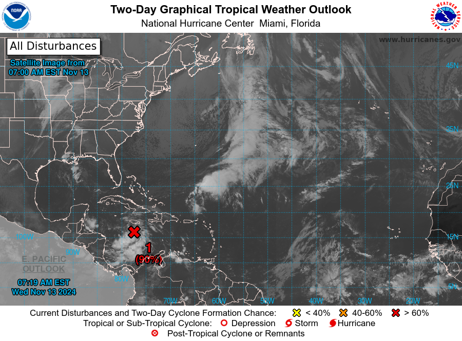
99L (Invest — Western Caribbean Sea)
Latest Observation
Last updated: Wednesday, 13 November — 6:00 AM Central Standard Time (CST; 12:00 UTC)
| ATCF | 6:00 AM CST (12:00 UTC) | |
|---|---|---|
| Current location: | 16.1°N 77.6°W | |
| Relative location: | 226 km (140 mi) SSW of Kingston, Jamaica | |
| Forward motion: | ▼ | SW (225°) at 5 km/h (3 knots) |
| Maximum winds: | 35 km/h (20 knots) | |
| Minimum pressure: | 1007 millibars (29.74 inches) | |
| 2-day potential: (through 6AM Fri) | ▲ | high (90 percent) |
| 7-day potential: (through 6AM Tue) | high (90 percent) |
Outlook discussion
Last updated: Wednesday, 13 November — 6:00 AM CST (12:00 UTC)
Discussion by Daniel Brown — NHC Hurricane Specialist Unit
A broad area of low pressure over the central Caribbean Sea continues to produce a large area of showers and thunderstorms. Environmental conditions are conducive for development, and a tropical depression is likely to form within the next couple of days while the system moves slowly westward into the western Caribbean Sea.
Afterward, further development is likely while the disturbance meanders over the western Caribbean Sea through the weekend. The system is expected to turn slowly northwestward by early next week. Interests across the western and northwestern Caribbean Sea should monitor the progress of this system.
Regardless of development, heavy rains are expected over Jamaica during the next day or so. For more information on this system, including gale warnings, see High Seas Forecasts issued by the National Weather Service. An Air Force Hurricane Hunter aircraft is scheduled to investigate this system later today.
Official information
National Hurricane Center (United States)
Text products
Graphical products
Surface analyses
Outlook graphics
Last updated: Wednesday, 13 November — 7:19 AM EST (12:19 UTC)
Meteorological Service of Jamaica
Instituto de Meteorología (Cuba)
Radar imagery
Meteorological Service of Jamaica
Radar imagery from the Meteorological Service of Jamaica is not currently available.
Instituto de Meteorología (Cuba)
Pilón radar (covers Jamaica)
Satellite imagery
Storm-specific imagery
- Tropical Tidbits: Visible / Shortwave Infrared
- Tropical Tidbits: Enhanced Infrared
- Tropical Tidbits: Enhanced Infrared (Dvorak)
- Tropical Tidbits: Water Vapor
- CIMSS: Multiple bands
- RAMMB: Multiple bands
- Navy Research Laboratory: Multiple bands
Regional imagery
National Oceanic and Atmospheric Administration (NOAA)
Cooperative Institute for Meteorological Satellite Studies (CMISS)
Tropical Tidbits
Weather Nerds
Analysis graphics and data
Wind analyses
- EUMETSAT: Advanced Scatterometer Data
Sea-surface Temperatures
- NOAA OSPO: Sea Surface Temperature Contour Charts
- Tropical Tidbits: Ocean Analysis
Model guidance
Storm-specific guidance
- Tropical Tidbits
- State University of New York at Albany
- National Center for Atmospheric Research (NCAR)
- Weather Nerds
Regional single-model guidance
Regional ensemble model guidance
Weather Nerds: GEFS (120 hours)
Weather Nerds: ECENS (120 hours)
20:09 UTC
Yinxing (24W — South China Sea)
Latest observation
Last updated: Tuesday, 12 November — 7:00 PM Indochina Time (ICT; 12:00 UTC)
| JTWC Warning #38 | 7:00 PM ICT (12:00 UTC) | |
|---|---|---|
| Current location: | 14.0°N 108.6°E | |
| Relative location: | 74 km (46 mi) WNW of Qui Nhon, Binh Dinh (Vietnam) | |
| Forward motion: | WSW (265°) at 15 km/h (8 knots) | |
| Maximum winds: | ▼ | 45 km/h (25 knots) |
| Intensity (SSHWS): | Remnant Low | |
| Minimum pressure: | ▲ | 1004 millibars (29.65 inches) |
^NOTE ^- ^Based ^on ^the ^Japan ^Meteorological ^Agency's ^ten-minute ^maximum ^sustained ^wind ^estimate ^of ^120 ^kilometers ^per ^hour ^(65 ^knots).
Official forecasts
Japan Meteorological Agency
The JMA is no longer issuing advisories for this system.
Joint Typhoon Warning Center
Last updated: Tuesday, 12 November — 10:00 PM ICT (15:00 UTC)
The JTWC is no longer issuing advisories for this system.
| Hour | Date | Time | Intensity | Winds | Lat | Long | |||
|---|---|---|---|---|---|---|---|---|---|
| — | UTC | ICT | Saffir-Simpson | knots | km/h | °N | °E | ||
| 00 | 12 Nov | 12:00 | 7PM Tue | Remnant Low | 25 | 45 | 14.0 | 108.6 | |
| 12 | 12 Nov | 00:00 | 7AM Wed | Remnant Low | ▼ | 20 | 35 | 13.9 | 107.0 |
| 24 | 13 Nov | 12:00 | 7PM Wed | Remnant Low | ▼ | 15 | 30 | 13.9 | 105.2 |
| 36 | 13 Nov | 00:00 | 7AM Thu | Dissipated |
Official information
Japan Meteorological Agency
Joint Typhoon Warning Center (United States)
National Meteorological Center (China)
National Center for Hydrometeorological Forecasting (Vietnam)
English
Vietnamese
Radar imagery
National Centre for Hydrometeorological Network (Vietnam)
Satellite imagery
Floater imagery
Single bandwidth imagery
- Tropical Tidbits: Visible / shortwave infrared
- Tropical Tidbits: Enhanced infrared
- Tropical Tidbits: Enhanced infrared (Dvorak enhancement)
- Tropical Tidbits: Water vapor
Multiple bandwidth imagery
The options to select individual bandwidths on each of the following websites may vary.
Regional imagery
Cooperative Institute for Meteorological Satellite Studies (CIMSS)
Weather Nerds
Analysis products
Best track data
Surface analysis products
Japan Meteorological Agency
Wind analysis and storm intensity estimation products
- NESDIS: Dvorak Fix History
- NESDIS: Multi-platform Surface Wind Analysis
- CIMSS: Advanced Dvorak Technique (ADT)
- CIMSS: Tropical Cyclone Intensity Consensus (SATCON)
- CIMSS: SATCON Intensity History
- EUMETSAT: Advanced Scatterometer Data
Sea-surface temperature analysis products
- NOAA OSPO: Sea Surface Temperature Contour Charts
- Tropical Tidbits: Ocean Analysis
Model products
Disturbance-specific model guidance
Storm-centered guidance
Track guidance
Track and intensity guidance
Regional single-model guidance
Regional ensemble model guidance
Weather Nerds: GEFS (120 hours)
Weather Nerds: ECENS (120 hours)
20:05 UTC
Usagi (27W — Philippine Sea)
Latest observation
Last updated: Saturday, 16 November — 8:00 AM Philippine Standard Time (PhST; 00:00 UTC)
| JTWC Warning #21 | 8:00 AM PhST (00:00 UTC) | |
|---|---|---|
| Current location: | 22.5°N 120.3°E | |
| Relative location: | 15 km (9 mi) SSW of Kaohsiung City, Taiwan | |
| Forward motion: | NE (50°) at 9 km/h (5 knots) | |
| Maximum winds: | ▼ | 55 km/h (30 knots) |
| Intensity (SSHWS): | ▼ | Tropical Depression |
| Intensity (JMA): | Tropical Storm [see note] | |
| Minimum pressure: | ▲ | 1002 millibars (29.59 inches) |
^NOTE ^- ^Based ^on ^the ^Japan ^Meteorological ^Agency's ^ten-minute ^maximum ^sustained ^wind ^estimate ^of ^65 ^kilometers ^per ^hour ^(35 ^knots).
Official forecasts
Japan Meteorological Agency
Last updated: Saturday, 16 November — 8:00 AM PhST (00:00 UTC)
| Hour | Date | Time | Intensity | Winds | Lat | Long | |||
|---|---|---|---|---|---|---|---|---|---|
| — | UTC | PhST | JMA | knots | km/h | °N | °E | ||
| 00 | 16 Nov | 00:00 | 8AM Sat | Tropical Storm | 35 | 65 | 22.2 | 120.2 | |
| 12 | 16 Nov | 12:00 | 8PM Sat | Tropical Depression ^1 | ▼ | 30 | 55 | 22.8 | 121.3 |
| 24 | 17 Nov | 00:00 | 8AM Sun | Tropical Depression | 30 | 55 | 23.4 | 121.7 |
Joint Typhoon Warning Center
Last updated: Saturday, 16 November — 11:00 AM PhST (03:00 UTC)
| Hour | Date | Time | Intensity | Winds | Lat | Long | |||
|---|---|---|---|---|---|---|---|---|---|
| — | UTC | PhST | Saffir-Simpson | knots | km/h | °N | °E | ||
| 00 | 16 Nov | 00:00 | 8AM Sat | Tropical Depression ^1 | 30 | 55 | 22.5 | 120.3 | |
| 12 | 16 Nov | 12:00 | 8PM Sat | Tropical Depression ^1 | ▼ | 25 | 45 | 23.4 | 121.2 |
| 24 | 17 Nov | 00:00 | 8AM Sun | Remnant Low ^1 | ▼ | 20 | 35 | 24.3 | 121.3 |
^NOTES:
^1 ^— Inland ^over ^Taiwan
^2 ^— Offshore ^to ^the ^east ^of ^Taiwan
Official information
Japan Meteorological Agency
Joint Typhoon Warning Center (United States)
Philippine Atmospheric, Geophysical, and Astronomical Services Administration
Central Weather Administration (Taiwan)
English
Chinese
Radar imagery
Central Weather Administration (Taiwan)
Satellite imagery
Floater imagery
Single bandwidth imagery
- Tropical Tidbits: Visible / shortwave infrared
- Tropical Tidbits: Enhanced infrared
- Tropical Tidbits: Enhanced infrared (Dvorak enhancement)
- Tropical Tidbits: Water vapor
Multiple bandwidth imagery
The options to select individual bandwidths on each of the following websites may vary.
Regional imagery
Cooperative Institute for Meteorological Satellite Studies (CIMSS)
Weather Nerds
Analysis products
Best track data
Surface analysis products
Japan Meteorological Agency
Wind analysis and storm intensity estimation products
- NESDIS: Dvorak Fix History
- NESDIS: Multi-platform Surface Wind Analysis
- CIMSS: Advanced Dvorak Technique (ADT)
- CIMSS: Tropical Cyclone Intensity Consensus (SATCON)
- CIMSS: SATCON Intensity History
- EUMETSAT: Advanced Scatterometer Data
Sea-surface temperature analysis products
- NOAA OSPO: Sea Surface Temperature Contour Charts
- Tropical Tidbits: Ocean Analysis
Model products
Disturbance-specific model guidance
Storm-centered guidance
Track guidance
Track and intensity guidance
Regional single-model guidance
Regional ensemble model guidance
Weather Nerds: GEFS (120 hours)
Weather Nerds: ECENS (120 hours)
20:04 UTC